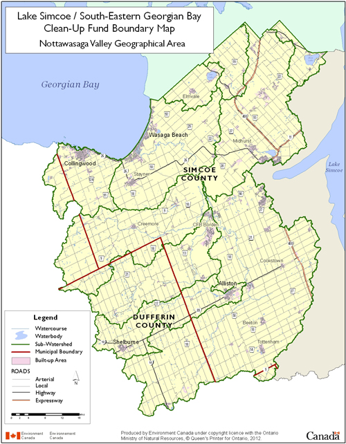
The Nottawasaga Valley Watershed is approximately 3,600 square kilometres of land and water (EC). The surface water can be broken down into three categories; there are 13 square kilometres of lakes, 585 square kilometres of stream systems, and 242 square kilometres of wetlands (EC). Georgian Bay forms part of the northern border and is also the final destination for the water which flows in at Collingwood, Wasaga Beach, and Severn Sound (NVCA). The area has been divided into 10 subwatersheds based on the different river, creek, and sound systems that drain the watershed.
The Townships of Adjala-Tosorontio, Clearview, Essa, Oro-Medonte, and Springwater, and the Towns of Bradford West Gwillimbury, Collingwood, Innisfil, New Tecumseth, and Wasaga Beach in Simcoe County, as well as the City of Barrie, the Towns of Mono and Shelburne, and Townships of Amaranth, Melancthon, and Mulmur in Dufferin County, and the Town of the Blue Mountains and Grey Highlands Municipality in Grey County and Town of Caledon in Peel Region are all represented either fully or partly in this watershed.
There are 26 square kilometres of coastal areas spaced along the 35 kilometres of Georgian Bay’s coastline (EC, NVCA). These areas are important to the tourism industry that is centred in Collingwood and Wasaga Beach. Agriculture covers a large portion of the land, but there are also areas of forest and wetlands (NVCA).
- Environment Canada. (2014, September 5). Lake Simcoe/South-eastern Georgian Bay Clean-Up Fund (LSGBCUF). In Environment Canada - Water - Lake Simcoe Clean-Up Fund. Retrieved September 15, 2014, from http://www.ec.gc.ca/eau-water/default.asp?lang=En&n=85C54DAE-1
- Nottawasaga Valley Conservation Authority. (2013). 2013 Nottawasaga Valley Watershed Health Check. In Watershed Report Cards. Retrieved September 29, 2014, from http://www.nvca.on.ca/Shared%20Documents/2013%20NVCA%20WHC.pdf

 RSS Feed
