|
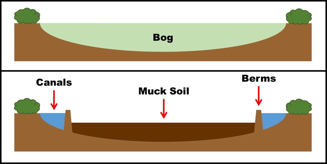
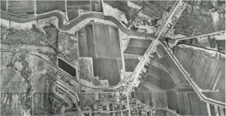
A polder is an area of low-lying land that has been reclaimed from a body of water and is protected by dyke and pump systems. Once the land to be reclaimed has been selected, dykes are built around the area. The water within the dykes is then pumped out of the area into a system of constructed canals (Figure 1). The land remaining is below the natural water level and pumps are used to continually remove water from the area. The polder is physically separate from the surrounding water system as the inflow and outflow are controlled through pumping stations. Natural seepage from ground water also contributes to maintaining soil moisture. The Dutch are well-known for their polders. They have reclaimed sea beds using this technique, holding back the sea with large dyke systems and pumps that were once powered by windmills. Other polders can be built to reclaim land from lakes, rivers, or bogs. Rich, fertile soils reside within these polders; once drained, polders have clay or muck soils, or a combination of the two. The land is largely flat and treeless, which is very suited to agriculture. Draining the Holland Marsh, named for the first Surveyor General of Upper Canada Major Samuel Holland, was a project led by Professor William Day of the Ontario Agricultural College beginning in 1925. The 28 km of canals dug then now protects 7,000 acres of prime muck soil. Pumping stations, one situated at the North Branch and the other at the northern end keep the water level low enough to keep the land dry. There is an additional 2,500 acres in smaller polders along the Holland River as it runs north to Lake Simcoe.
1 Comment
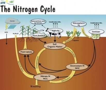
Nitrogen is an essential nutrient for the survival and growth of most living organisms. Nitrogen gas is a large constituent of the atmosphere, making up approximately 80% of the air, but this form is inaccessible by most plants. Certain bacteria in soils have the ability to ‘fix’ naturally-occurring nitrogen from the atmosphere, which converts it to a usable form for the plants, it can also be fixed by lightning or through an industrial process which makes nitrogen fertilizers. Nitrogen is generally the limiting nutrient in terrestrial ecosystems, and is applied to fields through use of fertilizers and manure. Once in the soil, the nitrogen will be used by the crops, leached down, or emitted into the atmosphere. In the soil, ammonium (NH4+) or ammonia (NH3) is broken down by bacteria through nitrification in which it is converted first to nitrite and then to nitrate. Both nitrites (NO2-) and nitrates (NO3-) are highly soluble forms of nitrogen and thus are transported easily in water and do not attach to the soil. Nitrite is more toxic than nitrate but since the processes changing nitrite to nitrate happen quickly it is not generally found in large quantities. Though less toxic, high concentrations of nitrate in aquatic systems can have both acute and chronic lethal effects on amphibians as well as any species which prey on amphibians, such as fish. NH3 which has not been converted through nitrification can also have harmful effects on aquatic organisms. The major sources of NH3 in aquatic systems are wastewater and treatment plants.
References
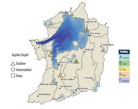
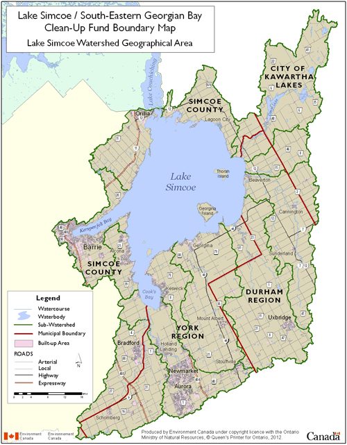
Part 2 of a 4-part series on watersheds The Lake Simcoe Watershed covers 3,576 square kilometres of land and water including the 722 square kilometres of Lake Simcoe which is part of the Trent-Severn Waterway (EC, LSRCA). There are 4,225 kilometres of rivers, creeks, streams, and tributaries divided into 18 separate subwatersheds (LSCRA). There are 35 rivers in total that empty into the lake and wetlands cover 13% of the watershed (EC, LSRCA) There are several regions and municipalities within this watershed. The Towns of Aurora, East Gwillimbury, Georgina, Newmarket, and Whitechurch-Stouffville and Township of King in York Region, the Towns of Bradford West Gwillimbury, Innisfil, New Tecumseth, Townships of Oro-Medonte and Ramara in Simcoe County, as well as the Cities of Barrie and Orillia, the Townships of Brock, Scugog, and Uxbridge in Durham Region, the City of Kawartha Lakes, and the Town of Caledon in Peel Region are all included in the watershed to some degree. Certain municipalities lie fully within the borders and others are only partly represented. The area hosts a permanent population of above 400,000 (LSRCA). The landscape is changing as the population grows and the towns are developing to service their needs. Its location close to Toronto has caused the towns in the southern areas to become bedroom communities for the city. Presently, 8% of the watershed is urban land and 36% is agricultural land (LSRCA). All aspects of Ontario agriculture are represented within this watershed. The Holland Marsh, located in the southwest, is known as the salad bowl of Ontario. It was designated a Specialty Crop Area in 2005 and is protected from urban expansion and non-agricultural uses. Recreational activities, predominately fishing, and tourism centred around the lake contribute $200 million to the local economy each year (EC). This watershed has an evolving landscape and must contend with increasing development. References
|
Project UpdatesFind articles on project-related topics here Archives
December 2016
Topics
All
Article TitlesIntroduction to
Watersheds Lake Simcoe Watershed Nottawasaga Valley Watershed South-Eastern Georgian Bay Watershed Water, Water, Everywhere? The Trouble with Muck: Size Lesson Learned: Bottom- up Aerator to Treat Washwater in Settling Tanks Phosphorus, the Environment, and Farming Nitrogen’s Impact on Air, Land, and Water Water-borne Pathogens and Food Safety Defining Dissolved Oxygen Filter Bags Demonstration Site Organic Matter Breakdown & Biochemical Oxygen Demand Dealing with Cloudy Water Hydrocyclone Demonstration Test What IS Muck? Demystifying Oxidation- Reduction Potential News Release "Technology Investigation: Filter Bags" Drum Filter Demonstration Site Decomposing With(out) Oxygen Flow monitoring Lesson Learned: Drum Filter Optimization Polders & the Holland Marsh Vegetable Washing Process Dry Soil Removal Ultrafiltration & Deionization Demonstration Site News Release "Technology Investigation: Ultrafiltration & Capacitive Deionization" Progressive Passive Filtration Dissolved Air Flotation Clarifying the Solid Removal Process Factsheet Reading Order News Release: "Technology Investigation: Coagulation & Flocculation" Self-Indexing Filter Monitoring Discharge Flows Settling Soil Mass Loading Calculations Lesson Learned: Technology Selection Electrocoagulation Auto-Samplers |
 RSS Feed
