HMGA Water Project
  • Home
  • Project Overview
    • Project Description
    • Project Team
    • Collaborative Projects
    • FAQ
  • Publications
    • Blog
    • Factsheets
    • News Articles
  • Events
  • Gallery
  • Dedirting
  • Contact

Polders & the Holland Marsh

9/8/2015

1 Comment

 
A polder is an area of low-lying land that has been reclaimed from a body of water and is protected by dyke and pump systems. Once the land to be reclaimed has been selected, dykes are built around the area. The water within the dykes is then pumped out of the area into a system of constructed canals (Figure 1). The land remaining is below the natural water level and pumps are used to continually remove water from the area. The polder is physically separate from the surrounding water system as the inflow and outflow are controlled through pumping stations. Natural seepage from ground water also contributes to maintaining soil moisture.
Picture
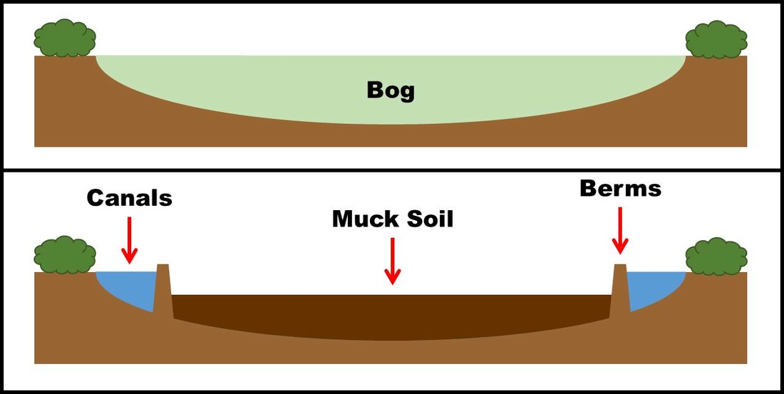
Figure 1: Side view of a bog (top) turned into a polder (bottom)
The Dutch are well-known for their polders. They have reclaimed sea beds using this technique, holding back the sea with large dyke systems and pumps that were once powered by windmills. Other polders can be built to reclaim land from lakes, rivers, or bogs. Rich, fertile soils reside within these polders; once drained, polders have clay or muck soils, or a combination of the two. The land is largely flat and treeless, which is very suited to agriculture. 
Picture
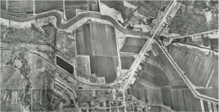
Figure 2: Overhead view of the northern end of Holland Marsh where the canals converge with the Holland River at the pumphouse [date unknown]
Draining the Holland Marsh, named for the first Surveyor General of Upper Canada Major Samuel Holland, was a project led by Professor William Day of the Ontario Agricultural College beginning in 1925. The 28 km of canals dug then now protects 7,000 acres of prime muck soil. Pumping stations, one situated at the North Branch and the other at the northern end keep the water level low enough to keep the land dry. There is an additional 2,500 acres in smaller polders along the Holland River as it runs north to Lake Simcoe.
1 Comment
Branden
8/20/2022 05:49:16 am

I notice the aerial picture of the marsh is covering the town of Bradford and the bridge leading to Newmarket, you can see the train tracks bridge adjacent to the other bridge, I would love to know the year of this and get a better zoom in because the house I grew up in is in this photo

Reply


Leave a Reply.

    Project Updates

    Find articles on project-related topics here

    Archives

    December 2016
    October 2016
    September 2016
    July 2016
    June 2016
    May 2016
    April 2016
    March 2016
    February 2016
    January 2016
    December 2015
    November 2015
    October 2015
    September 2015
    August 2015
    July 2015
    June 2015
    May 2015
    April 2015
    March 2015
    February 2015
    January 2015
    December 2014
    November 2014
    October 2014
    September 2014

    Topics

    All
    Aerators
    Coagulation & Flocculation
    Deionization
    Discharge Characterization
    Drum Filter
    Filter Bags
    General Information
    Hydrocyclone
    Lake Simcoe
    Lesson Learned
    Muck
    Nottawasaga Valley
    Pre Treatment
    Pre-Treatment
    Sampling
    Settling Ponds/Tanks
    South-Eastern Georgian Bay
    System Evaluation
    Treatment Technologies
    Ultrafiltration
    Washing Process
    Water Quality Parameters
    Watershed

    RSS Feed

    Article Titles

    Introduction to
      Watersheds

    Lake Simcoe Watershed
    Nottawasaga Valley
      Watershed
    South-Eastern Georgian
      Bay Watershed
    Water, Water,
      Everywhere?
    The Trouble with Muck:
      Size
    Lesson Learned: Bottom-
      up Aerator to Treat
      Washwater in Settling
      Tanks
    Phosphorus, the
      Environment, and
      Farming
    Nitrogen’s Impact on Air,
      Land, and Water
    Water-borne Pathogens
      and Food Safety
    Defining Dissolved
      Oxygen
    Filter Bags
      Demonstration Site
    Organic Matter
      Breakdown &
      Biochemical Oxygen
      Demand
    Dealing with Cloudy
      Water
    Hydrocyclone
      Demonstration Test
    What IS Muck?
    Demystifying Oxidation-
      Reduction Potential
    News Release
      "Technology
      Investigation: Filter
      Bags"
    Drum Filter
      Demonstration Site
    Decomposing With(out)
      Oxygen
    Flow monitoring
    Lesson Learned: Drum
      Filter Optimization
    Polders & the Holland
      Marsh
    Vegetable Washing
      Process
    ​Dry Soil Removal
    Ultrafiltration &
      Deionization
      Demonstration Site
    News Release
      "Technology
      Investigation:
      Ultrafiltration &
      Capacitive Deionization"
    Progressive Passive
      Filtration
    ​Dissolved Air Flotation
    Clarifying the Solid
      Removal Process
    Factsheet Reading Order
    News Release:
      "Technology
      Investigation:
      Coagulation &
      Flocculation"
    Self-Indexing Filter
    Monitoring Discharge
    ​  Flows
    Settling Soil
    Mass Loading
      Calculations
    Lesson Learned:
      Technology Selection
    Electrocoagulation
    Auto-Samplers
Powered by Create your own unique website with customizable templates.